New Hampshire census tract map
$ 45.00
In Stock - Shipping time: In Stock 2 weeks (aprox.)
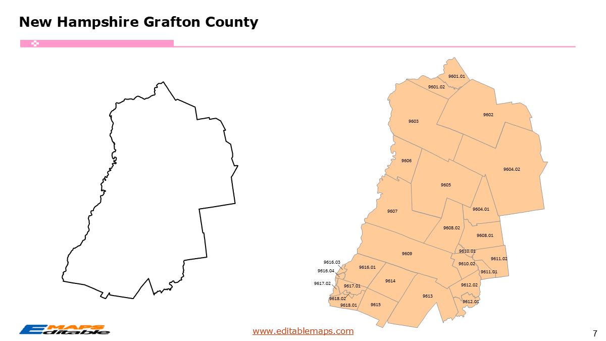
The New Hampshire census tract map by county templates in PowerPoint format includes 12 slides. Firstly, it is a blank US State map template. Secondly the New Hampshire map with 10 counties. Thirdly regarding the 349 census tracts, the New Hampshire census tract map by county product has grouped them by 10 counties, as PowerPoint templates are labeled with Census Tracts’ codes. The layers are grouped into two categories, one by Census Tracts shapes and the other by Census Tracts’ names, which makes it easier to customize your slides.The U.S. state of New Hampshire is divided into 10 counties, then further divided into 349 county Census Tracts. It is based on the latest 2020 Census Bureau TIGER/Line data.The 12 slides are listed below.US state map and New Hampshire Map of outline (1)New Hampshire Map with 10 Counties (1)New Hampshire 2020 census tract map PPT by county, Each County with its Census Tracts and codes labeled (10)The 10 counties and the number of their Census Tracts are as follows. Belknap County (18), Carroll County (19), Cheshire County (18), Coos County (11), Grafton County (28), Hillsborough County (103), Merrimack County (39), Rockingham County (72), Strafford County (30), and Sullivan County (11).New Hampshire is a state in the New England region of the Northeastern US. It is bordered by Vermont to the west, Maine and the Atlantic Ocean to the east, and Massachusetts to the south. To the north, it shares an international border with the Canadian province of Quebec. Known for its rugged landscape, the state is home to the White Mountains and the famous Mount Washington. Concord serves as the state capital, while Manchester is the largest city.The 327 New Hampshire Census TractsThe 327 census tracts in New Hampshire represent a significant increase from the 295 tracts used in 2010. This growth is primarily concentrated in the southern tier of the state as the “commuter rail” culture and tech expansion move north from Massachusetts.Hillsborough County: Contains the highest concentration of tracts, covering the urban centers of Manchester and Nashua.Rockingham County: Features a complex web of tracts along the Atlantic coastline and the busy I-93 corridor.The North Country (Coos County): Includes the state’s largest geographic tracts, some of which cover entire mountain ranges with sparse populations.About this Product: New Hampshire 327 Census Tract Master BundleThis bundle is designed for professionals needing a granular look at the Granite State. While New Hampshire has a smaller tract count than its southern neighbors, its geography is complex, ranging from high-density urban corridors to expansive rural mountain tracts.“About this Product: New Hampshire Census Tract Map Bundle (The Granite State Edition)”Master the geography of the North Country and the Seacoast with the New Hampshire Census Tract Map Bundle. This PowerPoint-ready toolkit features all 349 census tracts updated for the 2020 Census, allowing you to move beyond basic county-level reporting.Why this bundle is essential:349 Fully Editable Vector Shapes: Every census tract is a distinct object. You can ungroup, recolor, and label individual tracts to highlight specific market trends or service areas.Focus on Growth Centers: Includes detailed sub-maps for high-growth regions like the Manchester-Nashua corridor and the Seacoast (Portsmouth/Exeter).Organized by the 10 Counties: Slides are categorized by NH’s 10 counties (from Belknap to York), making it easy to find exactly what you need.If you want to get free US maps, please visit our affiliate’s website yourfreetemplates.com
Related product(s)
New Hampshire census tract map
$ 45.00
Maine census tract map by county
$ 45.00